WIVERN
A WInd VElocity Radar Nephoscope for observing global winds, clouds and precipitation
WIVERN mission selected by ESA as Earth Explorer 11 mission
after UCM in Prague on 9/7/2025
https://www.esa.int/Applications/Observing_the_Earth/FutureEO/ESA_selects_WIVERN_as_11th_Earth_Explorer_mission
https://atpi.eventsair.com/ee11ucm/
About WIVERN
Accurate weather forecasts are important to our daily lives, and in particular in support of emergency management during severe weather events. Wind, cloud and precipitation belong to the fundamental variables in NWP models, and the World Meteorological Organization (WMO) has defined in particular the lack of globally distributed direct wind observations as one of the main deficits of the current WMO Global Observing System. WIVERN will be the first space-based mission to provide in-cloud winds, and hence contribute to filling the gap in the current WMO Global Observing System to the benefit of NWP and climate research. WIVERN will also provide high-resolution reflectivity profiles of rain, snow and ice water, which can be used to achieve a better quantification of the Earth’s hydrological cycle and energy budgets, given the significant reduction in sampling errors compared to current and future cloud radar missions.

Primary Science Objectives
-
Understanding storms
-
Storm Structure and Dynamics
Improve the understanding of storm dynamics by quantifying the strength, structure, and horizontal extent of internal circulations across the full spectrum of storm types, from small convective systems just a few kilometres wide to large storms spanning up to 800 km, across Earth’s wide range of climates. Particular emphasis is on the role of in-storm horizontal mesoscale circulations and vertical wind shear driving the organisation and intensification of systems such as mesoscale convective systems, tropical and extratropical cyclones, and polar lows. -
Water, Heat, and Circulation
Gain insight into the coupling between water, heat and circulation by quantifying the relationship between the 3D mass structure, the 3D heat structure, and the resulting internal circulation as a function of storm type, and by characterising the relationship between storms, environmental mesoscale circulation, and large-scale circulation.
-
Storm Structure and Dynamics
-
Studying cloud and precipitation impacts on climate
-
Anvil Cloud Feedback
Determine the relationship between convective mass flux in tropical convective storms and the area and depth of the high anvil clouds they generate to better constrain climate sensitivity. -
Precipitating Oceanic Shallow Clouds
Improve quantitative estimates of shallow precipitation over the oceans in trade cumulus and stratocumulus regimes, and investigate how this precipitation influences the organisation of shallow clouds and affects the sign and magnitude of their climate feedbacks. -
Polar Snowfall
Improve the quantification and understanding of polar snowfall processes to reduce uncertainties in snowfall accumulation, assess surface mass balance, and better represent snow-related processes in climate and weather prediction models.
-
Anvil Cloud Feedback
-
Improving Numerical Weather Prediction (NWP) and Earth System Models (ESMs)
-
Numerical Weather Prediction
Improve the representation of the initial state of the atmosphere in Numerical Weather Prediction models, and hence, the quality of weather forecasts. -
Earth System Models
Advance the representation of cloud, precipitation, and associated dynamical processes in Earth System Models by providing global, high-resolution observations of in-cloud wind profiles and cloud properties. -
AI-Based Models
Improve AI-based weather forecasting models by providing unique observations as training and input data.
-
Numerical Weather Prediction
Secondary science objectives
- Bridging Observational Gaps in Polar Sea Ice and Snow for Climate Research
- Sea Ice Coverage
Enhance the resolution of sea ice concentration retrievals and of the statistics of leads (linear openings in the sea ice). - Snow on Sea Ice
Characterise properties of snow on sea ice, i.e. distinguish new, fresh-fallen snow from older, multi-layered snow, and estimate the depth of new snow.
- Sea Ice Coverage
- Revealing What Satellite Altimetry Misses: Advancing Our Understanding of Ocean Surface Current Dynamics
- Non-Geostrophic Ocean Currents
Characterise the spatial and temporal evolution of non-geostrophic ocean currents, and quantify their components that remain undetected by satellite altimetry (e.g., Ekman drift, Near-Inertial Oscillations, Equatorial currents, and tidal currents). - Air-Sea Interaction
Explore the potential of WIVERN concurrent measurements of surface currents and wind profiles to improve modelling and understanding of air-sea exchange processes.
- Non-Geostrophic Ocean Currents
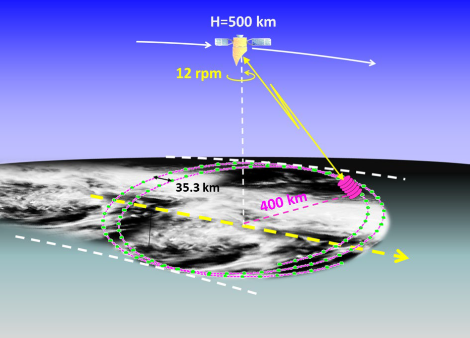
Instrument